HIPAA compliance maps easily built using ZeeMaps

We take security measures very seriously here at ZeeMaps. As a result, we are happy to report that we are HIPAA compliant.


HIPPA stands for Health Insurance Portability and Accountability Act. Which started in 1996. It includes measures to protect patient health data. Consequently, it affects any company that deals with protected health information (PHI). Therefore, they must make sure that physical, network, and process security measures are adhered to.

We meet HIPAA requirements

ZeeMaps is HIPAA compliant. So what does this mean for our users? Essentially, all it means you can rest assured that your data is completely secure.

For example, all user information and data are stored encrypted on a database. Therefore, data are not stolen or leaked. We use one of the strongest block ciphers available to encrypt data.

In addition, multi-factor authentication provides an extra layer of security.
The diagram below shows our infrastructure design. The diagram illustrates secure traffic flow from users to the ZeeMaps environment. This traffic flow helps to endure HIPAA compliance.

HIPAA compliant ZeeMaps secure infrastructure
HIPAA Compliant ZeeMaps secure infrastructure

HIPAA Patient-Provider Maps

You can use the secure ZeeMaps infrastructure to create patient-provider maps. First, create a spreadsheet of all your patient and provider locations. Next, add a column to the spreadsheet called Category. For values, you could enter phrases. Such as, “Patient”, “Physical Therapist”, or “Occupational Therapist”, etc.

Next, upload the spreadsheet to you HIPAA map on ZeeMaps.

Now, the map should show all your patients and providers. Including, patients and different kinds of providers colored differently.

Click View > Then, Search Menu

Search for providers within a certain distance of a patient, or an address. Limit the provider types by clicking on the legend at the bottom of the map.

Finally, to export the list of results as a spreadsheet. Use the “Export CSV”. (Found at the bottom of the Search dialog)

Business Associate Agreements

ZeeMaps can sign a Business Associate Agreement (BAA) for anyone who wants to use our service. A BAA is a contract between a HIPAA-covered entity and a business associate. Designed to protect patient health data in accordance with HIPAA guidelines.

Share maps with other users

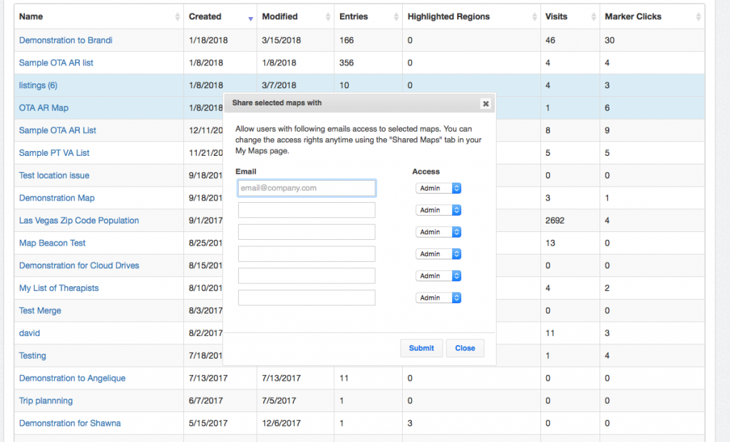
You can share your maps in ZeeMaps with other users, giving them controlled access.
To share your map, sign-in to ZeeMaps and go to the My Maps page. In the Owned map section, select the maps that you want to share by clicking on the map row anywhere except the title of the map. The selected rows will change to a blue background color. Then, use the Map Operations menu above the list, and the Share sub-menu within it to share the maps.
Share map from My Maps
This will bring up a dialog that allows you to specify the users with whom you want to share the maps, along with access rights that you want to give them, i.e., Viewer, Member or Admin.
Share map with specific privileges
Once you have shared the maps, they’ll become available to the other users in the Accessible tab of their My Maps section.
You can change access rights, or revoke the sharing anytime, by going to your Shared maps section in the My Maps page. The users with whom you have shared maps can also reject a sharing through their Accessible tab.

Map Location Search & Export List

The map location search capability in ZeeMaps allows you to search your map based on marker field values and geography, e.g., you can search for all “Gold” customers in California in a customer map on ZeeMaps.

First, use the View -> Search menu item on your map to bring up a search dialog as shown below:

Search Dialog Map Location
Search Dialog

How to Search the Map Locations

Section A of the search dialog is for limiting the search results to values in your marker fields. First, this input in this section allows you to select the field to search. Next, this drop-down is for selecting the predicate (e.g. contains, equals, etc.). Third, this input box is for the value to search. You can click on the AND or OR buttons to add up to four clauses for searching marker fields. Example: Name equals Jill

Section B allows you to combine your field search by distance or geography. Therefore, you can specify an address and a distance to limit the search results within a certain distance of your address or map location. Now, if you have highlighted regions in your map, e.g., the state of California, then you can limit the search results by clicking on the highlighted region. Normally search results are limited to 200 entries.

You can increase or decrease this number in Section C.

Then, to search the map locations, hit the Search button. You should see the status line at the bottom right of the map change. Now, it will reflect the number of entries that matched your search.

Export Matched Map Locations

Lastly, if you want to get a list of entries that matched your map location search and put them in a spreadsheet, you can hit the “Export CSV” button instead of the “Search” button. Normally, only map Admins are allowed to export the search results as CSV.

If you have any issues opening the .csv in excel try following these steps.

In case you want your members or viewers to also be able to export search results, use the Map -> Settings menu item and then the Map Security tab to change the default settings.

Maps published in secure (HTTPS) sites not showing in Firefox and Chrome

If you have a map published in a secure (https) site, please read on.
Recently Firefox and Chrome have stopped showing mixed mode (secure and non-secure) content through IFRAMEs.
In order for your secure published map to work in Firefox and Chrome, please get a new publish HTML code from ZeeMaps, or change the SRC URL of the IFRAME to HTTPS from HTTP.
Let us know if we can provide any additional assistance.

Secure access, radius regions, and updated Google Maps

Along with several improvements, today we  introduce some major new features for ZeeMaps:

  1. Secure https access,
  2. Radius Regions, and
  3. Updated Google Maps.

You can now access ZeeMaps using the https protocol. Google Ads will still show using the http protocol, so you may get warnings of mixed content in IE. To remove the mixed content warnings, please upgrade your account for an ads-free experience.
ZeeMaps already provides several region coloring mechanisms such as: hand-drawn, colored cities, states, countries, congressional districts, and so forth. In addition, we now support coloring a circular region on the map with a specified distance radius. Use  “Additions -> Radius Region” menu item on your map to draw a circular region on your map.
We have upgraded to the most recent version of Google Maps. You should see improved imagery and better speed across the board.
While we have tested thoroughly, there may be a few lingering inconsistencies or problems. Please let us know if your maps are not working as before.