
ZIP Codes—those seemingly random sets of numbers we enter when filling out forms with our personal information or ordering online—play a crucial role in the efficient delivery of mail and packages in the United States. But what exactly is a ZIP Code, and how does it work?
In this comprehensive guide, we’ll delve into the intricacies of these tools, from their history to their modern-day applications.
What Is a ZIP Code?
For starters, ZIP is an acronym for “Zone Improvement Plan,” a system of postal codes used by the United States Postal Service (USPS) to efficiently deliver mail. A ZIP Code consists of five digits that designates a specific geographical zone for mail delivery.
Contrary to popular belief, ZIP Codes are not delineated by state or county boundaries. Instead, they are designed to facilitate efficient mail delivery routes, and that means they often cross state and county lines. It’s true that most correspond to specific geographic areas, but some areas may overlap or have no defined geographic boundaries. Their primary function is making mail delivery more efficient, so some routes don’t fall firmly in one state or county.
The long and short of it is: each ZIP Code represents a collection of delivery routes served by a particular post office or mail distribution center.
Understanding the Structure
A standard ZIP Code consists of five digits. But did you know that each digit serves a specific purpose? Here’s what they mean:
- The first digit represents the national area or region of the United States (see our chart below for a breakdown).
- The following two digits specify the center facility or main processing center responsible for sorting mail within that region.
- The fourth and fifth digits narrow down the delivery area, getting into the nitty gritty about specific neighborhoods, towns, and even streets within the designated region.
Wondering how the regions are broken down in the United States? Here’s a comprehensive look at the states and territories.
| First Letter of the ZIP Code | U.S. State or Territory |
| 0 | Connecticut, Massachusetts, Maine, New Hampshire, New Jersey, Puerto Rico, Rhode Island, Vermont, Virgin Islands |
| 1 | Delaware, New York, Pennsylvania |
| 2 | Washington D.C., Maryland, North Carolina, South Carolina, Virginia, West Virginia |
| 3 | Alabama, Florida, Georgia, Mississippi, Tennessee |
| 4 | Indiana, Kentucky, Michigan, Ohio |
| 5 | Iowa, Minnesota, Montana, North Dakota, South Dakota, Wisconsin |
| 6 | Illinois, Kansas, Missouri, Nebraska |
| 7 | Arkansas, Louisiana, Oklahoma, Texas |
| 8 | Arizona, Colorado, Idaho, New Mexico, Nevada, Utah, Wyoming |
| 9 | Alaska, American Samoa, California, Guam, Hawaii, Marshall Islands, Federated States of Micronesia, Northern Mariana Islands, Oregon, Palau, Washington |
Why Do We Have ZIP Codes?
The concept of ZIP Codes was introduced by the USPS in 1963 as a means to streamline mail delivery and improve efficiency. Prior to the implementation of this tool, mail sorting and delivery processes were time-consuming and often prone to errors. By assigning unique numerical codes to different geographic regions, the USPS was able to automate and optimize the sorting and delivery of mail.
Then, in 1983, the USPS introduced ZIP+4 Codes as an extension of the standard five-digit system. A ZIP+4 Code includes the basic five digits, followed by an additional four digits that provide even more precise information about a specific delivery location. They enable mail carriers to pinpoint individual addresses, such as apartment buildings or office complexes, within larger areas.
ZIP Code Lookup and Applications
With the advent of digital technology, accessing ZIP Code information has never been easier. Online tools from USPS and other databases allow users to look up ZIP Codes by entering addresses, city names, or other information. They’re a convenient tool when you’re mailing a letter, shipping a package, or verifying an address.
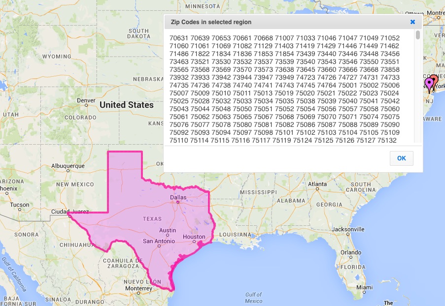
You can also use ZIP Codes when creating a map. For example, ZeeMaps supports ZIP Code Lookup. Using this tool, you can select a geographic region and then figure out which codes are associated with that region. You are not limited to using pre-defined regions, since ZeeMaps allows you to define arbitrary areas with hand-drawn shapes, making it easy to determine ZIP Codes for any region on the map.
In summary, ZIP Codes are a fundamental component of the United States postal system, facilitating the efficient sorting and delivery of mail and packages. From their inception in the 1960s to their modern-day applications, these five-digit numbers have revolutionized the way we navigate and interact with the postal infrastructure.
Inspired by this map?
Create your own interactive map with ZeeMaps in minutes.