We’ve added the capability to highlight states, cities in map of Australia, and states, counties, cities in map of France. Since France does not use states, counties and cities, we’ve approximated them with Regions, Departments, and Communes, respectively.
For example, to highlight the state of Queensland in map of Australia, create a map and then click on the menu item Additions -> Highlight Regions -> States. In the resulting dialog, select Australia as the country and then Queensland as the state. Customize your boundary and fill color and hit Submit.

This should add highlight Queensland in the following map of Australia:
Here’s the same map with Paris Department (county) highlighted:
Category: Colored Regions
List markers within a region
To list all markers that fall within a region, use the menu item View -> Search. In the resulting dialog, as shown below, customize your search. We’ve highlighted the part that you need for setting the desired region.

Click on the “Map Select Region” to select the region for limiting the search. You can combine it with any of the other clauses, e.g., names that contain the string ‘doctor’, etc. You should have defined at least one region on your map (using the Additions -> Highlight Regions menu item) for this to work.
Once you’ve set the parameters, hit the “Search” button. This should limit the marker display on the map to only those markers that meet your search criteria and are within the selected region. To see the count, look at the status bar at the bottom right of the map. To see a list, click View -> Show List menu item. To get a list to print, click on the Print button in the search dialog.
World Map
You can easily get a customized world map image with ZeeMaps.

First, create a map using the “Create a Free Map” button on the ZeeMaps site.
Use the Additions -> Add Marker menu items on your map to add your own locations to your new map. You can also add multiple locations in batch by using the spreadsheet uploads options.
If you want to highlight certain countries, states, etc., use the Additions -> Highlight Regions menu item.
Once you have your customizations done, you can get a world map by using the Print or Share -> World Map Image menu item, which will bring up a customization dialog:
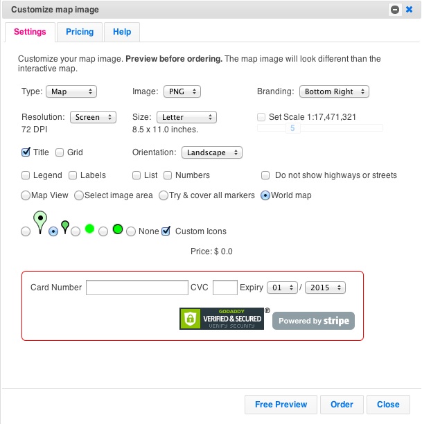
Use this customization dialog to customize your image, e.g., set the size, resolution, kind of markers (pins) to show your location, etc. Experiment with different customizations by hitting the Preview button. Once you’re satisfied with the Preview, enter your payment information and hit Order.
The image of a world map will be generated and stored on our servers. You’ll get a link to download the image. Remember the link URL in case you want to retrieve the image later.
Here another world map of the image at the top of this post, as a regular map instead of a satellite image.

Region improvements and pricing
We’ve made it easier to specify color and boundaries, when you add or update a geographical or geometrical region on your map. Instead of specifying a color number and opacity, you can now select a color from a color picker and use an opacity slider.

With this change, we are also limiting the number of regions you can add per map depending on your subscription level as follows:
- Basic: 5 regions per map
- Professional: 10 regions per map
- Professional Publisher: 15 regions per map
- Enterprise: Unlimited regions per map
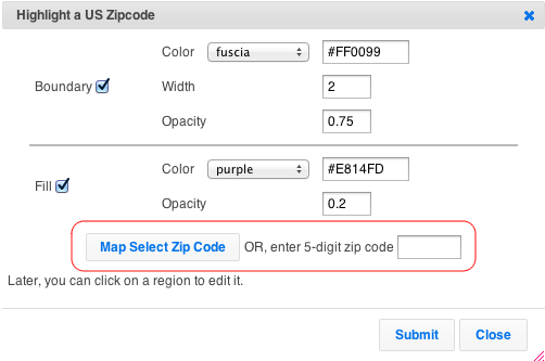
Zip Code – Highlight and Color US Counties
Use the Additions -> Highlight US County, or Additions -> Highlight US Zip Code to color any zip or county in the US.

For Zip Codes, you can either specify a five digit zip. Or, click on the map to get the value for locations.
For Counties, select a state and county.
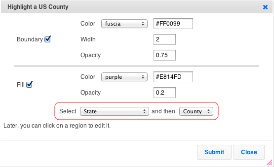
As all highlighted regions in ZeeMaps, counties and zip codes regions have a boundary and fill, which can be customized for color, etc..
Once you’ve created a region, you can make changes to it by accessing your map as Admin. Then, click on a region to modify it. In the case of countries, states, counties, cities, or zip, you can change the boundary and fill coloring at any time. With hand-drawn regions, you can also change the shape. For radius regions, you can additionally change the size and location.
For example, below is a map of Los Angeles with the famous 90210 (Beverly Hills) area highlighted.
The highlighted regions work both on the interactive maps and the static images, as shown in the image below.

Find your Zip Code data
Under the OPEN Government Data Act, which is Title II of the Foundations for Evidence-Based Policymaking Act, government data is required to be made available in open, machine-readable formats, while continuing to ensure privacy and security.
You can search Data.gov from its catalog of government data from across the Federal Government. Once in the catalog, to find datasets you can:
- Enter keywords in the search box.
- Browse on the left side through types, tags, formats, groups, organization types, organizations, and categories. Clicking on multiple items narrows your search. You can click on the “x” to the side of any single item to remove it from the search, or “clear all” to remove all selected items in a category.
- Search by geospatial area by drawing a boundary box on the map at the left side and clicking “Apply” to find all datasets that are tagged for that geographic area.
Click here for more information on locating zip code data