Zip Code Finder and County Maps with Labels


With ZeeMaps, you can build a Zip Code Finder or County maps. By highlighting certain Zip Codes (in the US) and counties (in US, France and UK).
You can style the highlighted area by picking the color and the region, size, color and opacity of the boundary. But with a recent upgrade, the regions will now be automatically labeled with their number or name on your Zip Code Finder or County map. The labels should help in easily identifying the county or zip code. For example, the following map shows a zip code finder map for Los Angeles. But with Beverly Hills (90210) highlighted. (For more information on highlighting regions, please see our Help section.)

To avoid cluttering of the map, the labels will show only at higher zoom levels. Some Regains such as zip codes, are automatically labeled.
There is a limit of 175 regions for the labeling. If your map has more than 175 regions, then they will not be labeled. So we restrict the number of labels to ensure that the map is displayed in reasonable time. Let us know if you’d like to see maps with larger number of regions labeled. As shown below if some highlighted regains have zip codes if will put them in for you.

Create Your Own Map!

Use our tutorial to create your own map!

1: Create your map

2: Share on social

3: Tag ZeeMaps! #ZeeMaps #WeMapYourLists

Zip Code Finder Example Map

View and interact with our example map below. What labels do you see? Try adding a highlighted region!

Adding Concentric Circles on a Radius Map

ZeeMaps makes it easy to add concentric circles on a radius map.
To add your concentric circles, create your radius map, and click on the menu item Highlight Regions -> Circles.

Menu item to Add Circles
Add Circles to a Radius Map

This should give you a dialog to specify your circles center, and enter multiple radiuses (separated by commas or spaces) for the circle in miles. Customize the fill and boundary color specifications and Submit. For example, in the following dialog, we have specified a set of five concentric circles centered around Paris.

Radius Map with concentric circles
Specify concentric circles for a Radius Map

To specify the center for the circles, you can either select the location by clicking on the map or enter the geographical coordinates as latitude and longitude (decimal format).
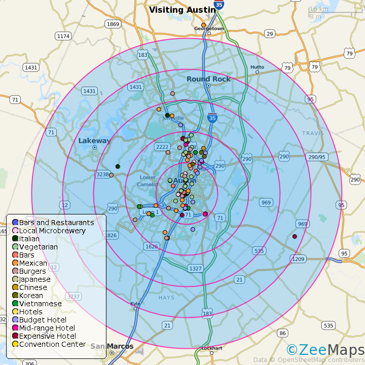
We did this on our demonstration map, Visiting Austin, by creating concentric circles around the hotel that someone might be staying in. The interactive map resulting from this, is shown below:

Once you have added concentric circles, you can modify them by clicking on any of the circle. You can change the radius of the clicked circle by dragging one of the empty dots on the circumference. To modify the center of all the circles, drag the center of the clicked circle. Finally, you can change the fill or boundary of all the circles by changing them on the clicked circle.
The circles will show on print images as well. For example, here’s a small PNG image from the map that we created above.

Attractions within five miles of hotel
Attractions within five miles of Hotel

Change all markers in California to Yellow in a US Map

Bulk edits of map information has a “Copy Changes” feature. Select multiple rows, make a change to one row, and then click on “Copy Changes” to make the same change to all the selected rows.
For example, suppose we have a US map of locations in different states and we want to color all the markers in California to Yellow.
On your map, click on the Bulk Edits -> Markers menu item (this requires a paid subscription).

Bulk Edit menu item
Bulk Edit of Markers

This opens up a new tab in the browser with an edit grid for all the locations on the map. Sort this grid using the “State” column, and select all rows from California. Change the “Marker” cell of one row to “Yellow” and hit “Copy Changes”. The change is propagated to all the selected rows. Pressing “Save Changes” will commit these changes.
Change multiple rows at once with CopyChanges

Highlight administrative areas in map of Australia and France

We’ve added the capability to highlight states, cities in map of Australia, and states, counties, cities in map of France. Since France does not use states, counties and cities, we’ve approximated them with Regions, Departments, and Communes, respectively.
For example, to highlight the state of Queensland in map of Australia, create a map and then click on the menu item Additions -> Highlight Regions -> States. In the resulting dialog, select Australia as the country and then Queensland as the state. Customize your boundary and fill color and hit Submit.

Highlight the state of Queensland in Australia

This should add highlight Queensland in the following map of Australia:

Here’s the same map with Paris Department (county) highlighted: