
How far can a customer really drive in 15 minutes? A circle on a map cannot tell you — rivers, highways, and dead-end streets all bend the answer. An isochrone map can.
With ZeeMaps’ new Drive-Time Areas, you can highlight the area reachable within a chosen drive time of any location. Draw one around a single address, around every pin on your map, or around thousands of locations imported from a spreadsheet.
Moreover, the feature is available everywhere you work with ZeeMaps: interactively from the map menu, in bulk through CSV and Excel uploads, and programmatically through the ZeeMaps REST API.
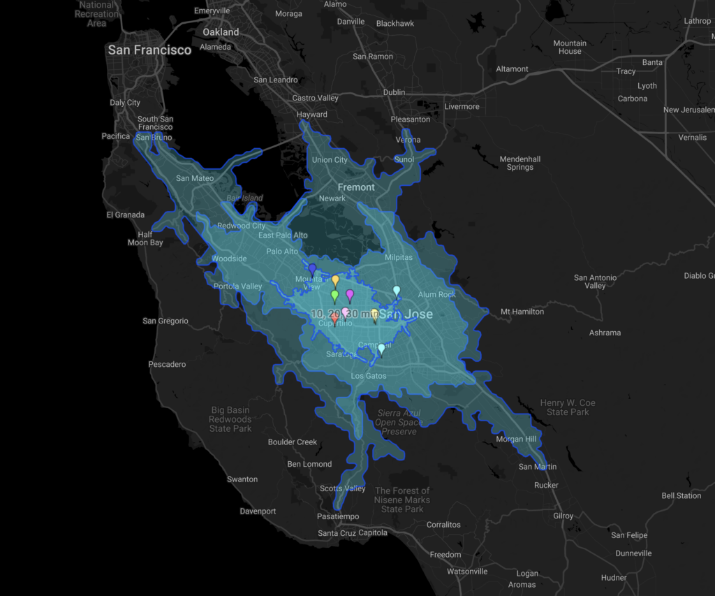
What Is an Isochrone Map?
An isochrone map — also called a drive-time map — shows everything you can reach from a starting point within a set amount of travel time. A plain radius map answers “what is within 10 miles?” An isochrone map answers the question people actually ask: “what is within a 15-minute drive?”
Because the shape follows the real road network, it stretches along fast corridors and pulls back at rivers, mountains, and dead ends. You may also hear these shapes called a travel time map or a drive time radius map — they are all the same idea.
In ZeeMaps, drive times are computed for car travel over current road data, and results are cached, so repeated requests draw instantly.
Highlight a Drive-Time Area Around One Location
The quickest way to create an isochrone map is from the map itself:
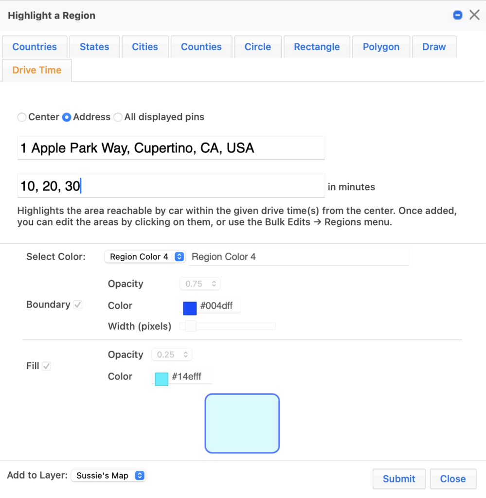
- From your map’s Additions menu, choose Highlight Regions.
- Click the Drive Time tab.
- Pick an origin: Center (use Map Select or enter a latitude and longitude), Address, or All displayed pins to draw an area around every pin currently shown.
- Enter one or more drive times in minutes — for example, “10, 20, 30” creates three nested bands.
- Choose boundary and fill colors, then add the areas to your map.
Each area is labeled with its drive time at the origin — “15 min” — and nested bands around the same point share a combined label such as “10, 20, 30 min”. Interactive requests accept 1 to 120 minutes and up to 50 areas at a time. If you change an area’s drive time later, ZeeMaps recomputes the shape from the same origin automatically.
Bulk Isochrone Maps from a CSV or Excel Upload
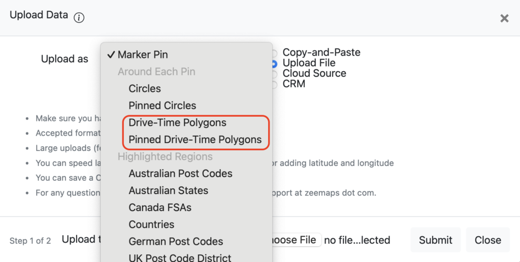
Need a drive-time area around every store, clinic, or technician in a spreadsheet? Upload the file as usual and, under Around Each Pin in the marker-type list, choose Drive-Time Polygons (always visible) or Pinned Drive-Time Polygons (shown when a pin is clicked).
During upload, set a Default Drive Time in minutes for the whole file. In addition, if your spreadsheet has a Drive Time column, ZeeMaps recognizes it automatically and uses the per-row value instead.
That is all it takes to turn a plain location list into an isochrone map of your service coverage.
Create an Isochrone Map from the API
Everything above is also available to your code — or to your AI assistant, as we showed with the ZeeMaps REST API. The bulk-import endpoint accepts the same spreadsheets, with two marker types: drive_time and pinned_drive_time.
curl -X POST "https://api.zeemaps.com/v1/maps/YOUR_MAP_ID/markers/bulk?marker_type=drive_time&default_drive_time=15" \
  -H "Authorization: Bearer $ZEEMAPS_API_KEY" \
  -H "Content-Type: text/csv" \
  --data-binary @locations.csv
The per-row drive_time column works here too, and default_drive_time sets the fallback for rows without one. API access is part of the Enterprise plan; the ten-minute quickstart at apidocs.zeemaps.com walks you through minting a key.
What Can You Do with a Drive-Time Radius Map?
- Service areas: show which customers fall within 30 minutes of each field technician, office, or warehouse.
- Delivery zones: publish an honest “we deliver within 20 minutes” boundary instead of a hopeful circle.
- Real estate: give buyers a commute time map — every home within 15 minutes of downtown or a school.
- Site selection: compare candidate locations by their 10-minute reach, then color them by data value.
- Healthcare access: map which neighborhoods sit within 20 minutes of your clinics.
Related articles:
- Graduated, Data-Driven Colors for Your Pins and Regions
- Automate Your Maps: Introducing the ZeeMaps REST API
- Add US Census Demographics to Your Maps
Good to Know
- Drive-time areas take their color from your map’s palette, so they participate in the legend, category filtering, and printing like any other region.
- Duplicate requests — the same origin and minutes — are combined automatically, and results are cached, so large uploads render fast.
- Travel mode is driving, based on typical road speeds rather than a single rush-hour snapshot.
- Drive-Time Areas work on your existing maps — there is no need to re-create anything.
Final Thoughts
Distance is a number; drive time is an answer. An isochrone map replaces “within 10 miles” with what customers, patients, and employees actually experience on the road.
Open Additions → Highlight Regions on any of your maps, click the Drive Time tab, and see what 15 minutes really looks like.