
Fall color moves across the United States in waves, and a fall foliage map is the easiest way to follow them. Color can begin in Alaska and the highest mountain country in September, spread through New England, the Great Lakes, and the Rockies in early October, and continue into the Appalachians and the South through late October and November.
This interactive fall foliage map brings together 32 of the best-known places to see autumn colors in the U.S. Use it to find scenic drives, national parks, mountain towns, lakes, waterfalls, and hiking areas that fit your route.
The dates on this map are typical peak-color windows, not a live forecast. Weather, elevation, rainfall, wind, and temperature can shift the season from year to year, so check the official destination link before making firm travel plans.
Interactive Fall Foliage Map
Click a marker to see the destination, its typical peak window, what it is best known for, and a link to the official park or tourism website. Marker colors group destinations by the usual timing of their strongest fall color.
How to Use This Fall Foliage Map
A list can tell you which places are famous for fall colors, but a map makes trip planning much easier. You can quickly see which destinations are close to one another, which ones fit a regional road trip, and how the season generally progresses from north to south and from high elevations to lower elevations.
The map helps answer practical questions such as:
- Where can I see fall foliage near my travel route?
- Which destinations usually peak in September, October, or November?
- Can I combine several foliage stops into one road trip?
- Which locations offer scenic drives rather than long hikes?
- Where does the foliage season last longest because of elevation changes?
Fall Foliage Timing at a Glance
Peak color does not arrive everywhere at once. Northern areas and high mountain elevations usually change first. Lower elevations and southern forests generally follow later. These windows are broad planning guides rather than exact annual predictions. The marker colors on the fall foliage map above follow the same five timing groups.
| Destination | State | Typical Peak Window |
|---|---|---|
| Denali National Park | Alaska | Early to mid-September |
| North Cascades National Park | Washington | Late September to early October |
| June Lake Loop | California | Late September to mid-October |
| Maroon Bells | Colorado | Late September to early October |
| San Juan Skyway | Colorado | Late September to early October |
| North Shore Scenic Drive | Minnesota | Late September to early October |
| Porcupine Mountains | Michigan | Late September to early October |
| Kancamagus Highway | New Hampshire | Late September to early October |
| Stowe and Green Mountain Byway | Vermont | Late September to early October |
| Adirondacks and Lake Placid | New York | Late September to early October |
| Acadia National Park | Maine | Early to mid-October |
| Door County | Wisconsin | Early to mid-October |
| Catskill Mountains | New York | Early to mid-October |
| Berkshires and Mohawk Trail | Massachusetts | Early to mid-October |
| Ohiopyle and Laurel Highlands | Pennsylvania | Early to mid-October |
| Hocking Hills State Park | Ohio | Mid to late October |
| Shenandoah and Skyline Drive | Virginia | Mid to late October |
| New River Gorge | West Virginia | Mid to late October |
| Great Smoky Mountains | Tennessee / North Carolina | Mid-October to early November |
| Natchez Trace Parkway | Mississippi / Tennessee | Late October to mid-November |
Best Fall Foliage Destinations by Region
The regions below match what you will see as you move around the fall foliage map. Nearby markers that share a color usually peak together, which makes it easier to build a route.
New England and the Northeast
New England is the best-known fall foliage region in the country, and for good reason. The Kancamagus Highway in New Hampshire, Stowe in Vermont, Acadia National Park in Maine, and the Berkshires in Massachusetts combine dense hardwood forests with mountain roads, villages, covered bridges, and lakes.
Farther west, the Adirondacks usually begin changing before the Catskills. That gives travelers in New York a useful way to follow the season: higher and more northern areas first, followed by lower and more southerly destinations.
The Great Lakes and Midwest
The Upper Midwest can deliver exceptional color before many better-known eastern destinations. Minnesota’s North Shore Scenic Drive, Michigan’s Porcupine Mountains, and Wisconsin’s Door County combine autumn forests with lakeshore scenery.
Later in October, Hocking Hills, Brown County, and Cuyahoga Valley offer colorful forests, waterfalls, ravines, and scenic roads that are accessible from many Midwestern cities.
The Rocky Mountains and the West
Western fall foliage often centers on aspens and larches rather than the broad hardwood forests of the East. Maroon Bells and the San Juan Skyway in Colorado are especially well known for golden aspens. The Eastern Sierra, Flagstaff, northern New Mexico, Glacier, Mount Rainier, and the North Cascades provide additional high-elevation choices.
Timing can be brief in mountain areas. A storm or strong wind can remove leaves quickly, so flexibility is especially valuable when planning a western foliage trip.
The Blue Ridge, Appalachians, and the South
The Blue Ridge Parkway and Great Smoky Mountains National Park have unusually long foliage seasons because their roads cross a wide range of elevations. Color can begin on higher ridges and gradually move down toward valleys over several weeks.
Shenandoah, New River Gorge, Tallulah Gorge, the Talimena Scenic Drive, and the Natchez Trace extend the season into late October and November. These routes are useful for travelers who miss the early peak farther north.
Ideas for Fall Foliage Road Trips
Each of these trips can be planned directly from the fall foliage map: pick an anchor destination, then add nearby markers that usually peak in the same window.
Classic New England Loop
Combine Vermont’s Green Mountains, New Hampshire’s Kancamagus Highway, and western Maine. Add Acadia if you have enough time for the coast.
Great Lakes Color Route
Build a trip around Minnesota’s North Shore, Michigan’s Upper Peninsula, or Door County. These destinations pair colorful forests with dramatic water views.
Colorado Aspen Circuit
Use Aspen and Maroon Bells as one anchor and the San Juan Skyway as another. The route works best when you can adjust dates around current local color reports.
Blue Ridge and Smokies
Travel the Blue Ridge Parkway toward Great Smoky Mountains National Park. Because elevation changes constantly, this route often provides several chances to find good color.
Tips for Planning a Fall Color Trip
- Check local reports close to departure. Typical dates are useful for choosing a week, but current conditions are more important. The U.S. Forest Service fall colors page and state tourism sites post seasonal updates.
- Pay attention to elevation. Mountain ridges can peak well before nearby valleys.
- Build in flexibility. Wind, rain, heat, drought, and early frost can speed up or shorten the display.
- Reserve busy destinations early. New England inns, national-park lodging, and popular mountain towns can fill quickly.
- Start early in the day. Scenic roads and trailhead parking are much easier before midday on peak weekends.
- Use official websites. Road closures, shuttle systems, parking reservations, and seasonal services vary by destination.
How This Fall Foliage Map Was Made
We created this interactive map with ZeeMaps. Each destination was added from a spreadsheet containing its name, coordinates, typical peak window, region, description, and official website.
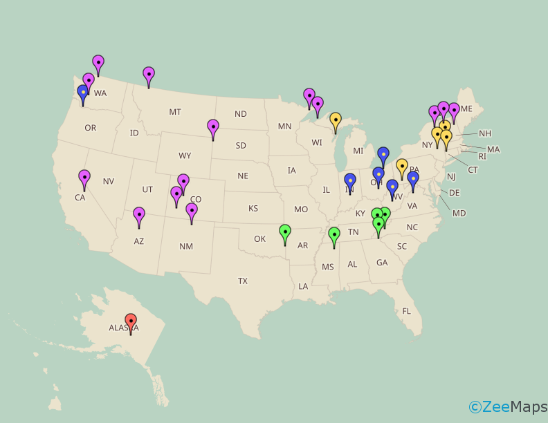
ZeeMaps automatically turns the spreadsheet rows into clickable markers and builds a legend from the peak-time categories. The finished map can be explored online, shared by link, or embedded directly in a WordPress page.
The same method works for scenic drives, parks, gardens, hiking trails, holiday displays, festivals, customer locations, sales territories, and almost any other collection of places.
Create Your Own Travel Map
Planning a road trip, publishing a destination guide, or organizing a collection of local attractions? ZeeMaps can turn a CSV, Excel file, or Google spreadsheet into an interactive map in minutes.
You can customize marker groups, add photos and links, search your entries, create a legend, and publish the result on your own website.
Frequently Asked Questions
When is the best time to see fall foliage in the United States?
The broad U.S. season runs from September into November. Alaska and high mountain areas can turn in September, much of the Northeast and Midwest peaks in October, and parts of the South continue into November.
Is this a live fall foliage prediction map?
No. This map focuses on destinations and their typical peak windows. Use it to choose possible places and routes, then check current local foliage reports before traveling.
Why do peak dates change every year?
Temperature, rainfall, drought, wind, frost, elevation, and tree species all affect when leaves change and how long they remain on the trees.
Where does fall foliage begin first?
Color usually begins first in northern latitudes and at high elevations. Denali, the northern Rockies, the Cascades, and high Colorado and Sierra locations can all change before lower and more southern destinations.
Where can I see late fall foliage?
The southern Appalachians, Talimena Scenic Drive, Tallulah Gorge, and the Natchez Trace are good places to look later in the season, often from late October into November.
Can I make a fall foliage map from a spreadsheet?
Yes. ZeeMaps can import a spreadsheet with destination names, addresses or coordinates, categories, descriptions, websites, and photo URLs. It then creates the markers automatically.
Can I embed a fall foliage map on my website?
Yes. ZeeMaps provides publishing code that can be pasted into WordPress, blogs, travel sites, local tourism pages, and other websites.
Explore More Maps
Planning other seasonal trips? Visit the U.S. State Fair Map or browse more interactive maps in the World of Maps gallery.
Inspired by this map?
Create your own interactive map with ZeeMaps in minutes.